Bountiful Roebuck Bay
Editor’s Note: Today’s story is the answer to the August Puzzler.
Tides are among the clearest signs of the Moon’s pull on Earth. Just 239,000 miles (385,000 kilometers) away, the Moon’s gravity pulls on Earth’s oceans and solid crust, subtly distorting them into a more oblong shape with bulges roughly extending toward and away from the Moon.
High tides happen throughout Earth’s oceans, but in some places they leave an unusually strong fingerprint on the landscape. Among those places is Roebuck Bay, a crescent-shaped feature in the Kimberley region of Western Australia.
Roebuck Bay’s tidal range can reach a remarkable 9 meters (30 feet). Rising and falling tides repeatedly inundate and expose expansive mudflats, flood broad mangrove forests and salt marshes, and feed branching networks of tidal drainage channels. Many parts of Australia have tidal ranges of 2 meters or less. But the large range at Roebuck Bay is mostly a consequence of northwestern Australia’s unusually wide, shallow continental shelf, which helps amplify tides as they approach the coast.
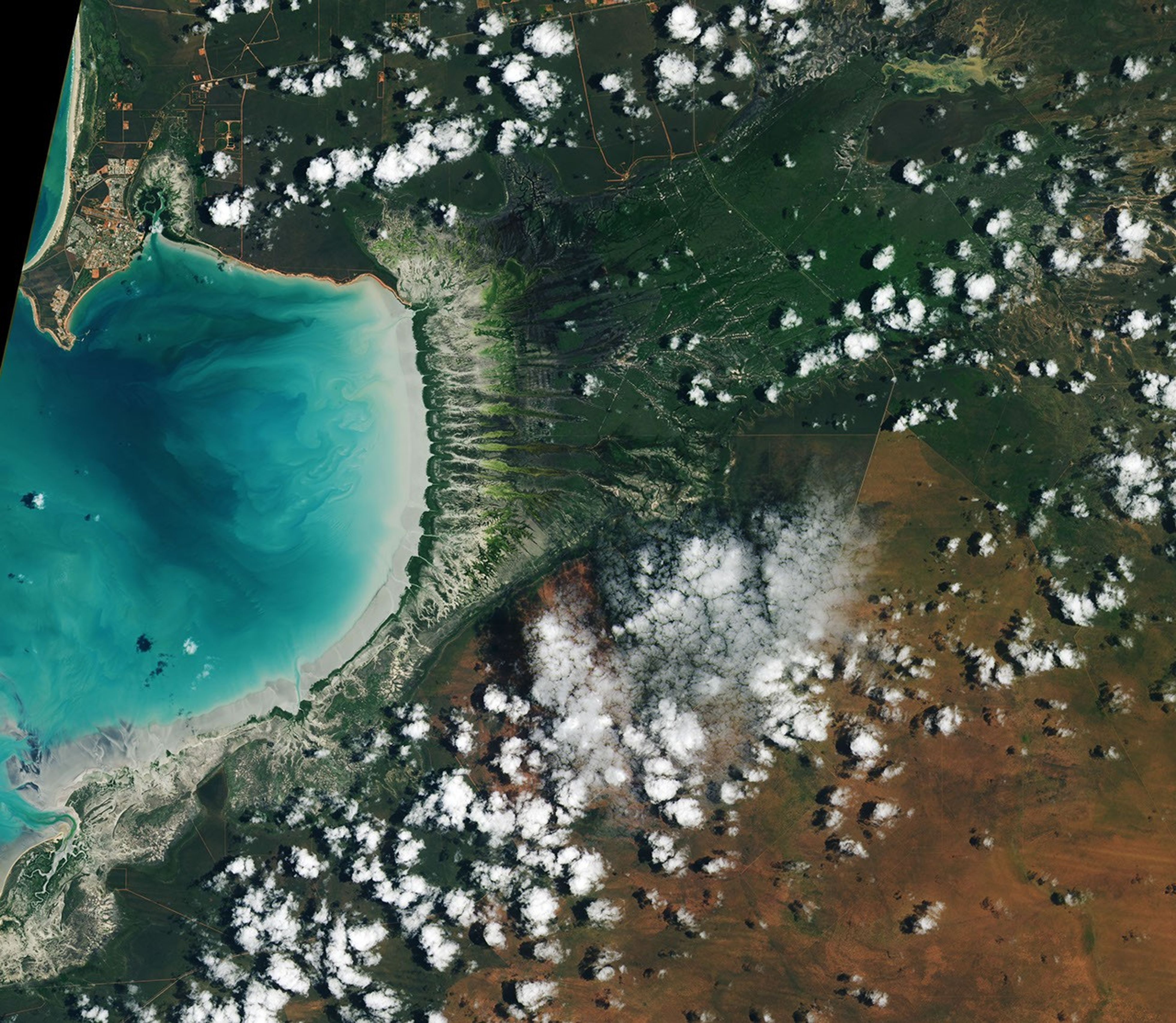
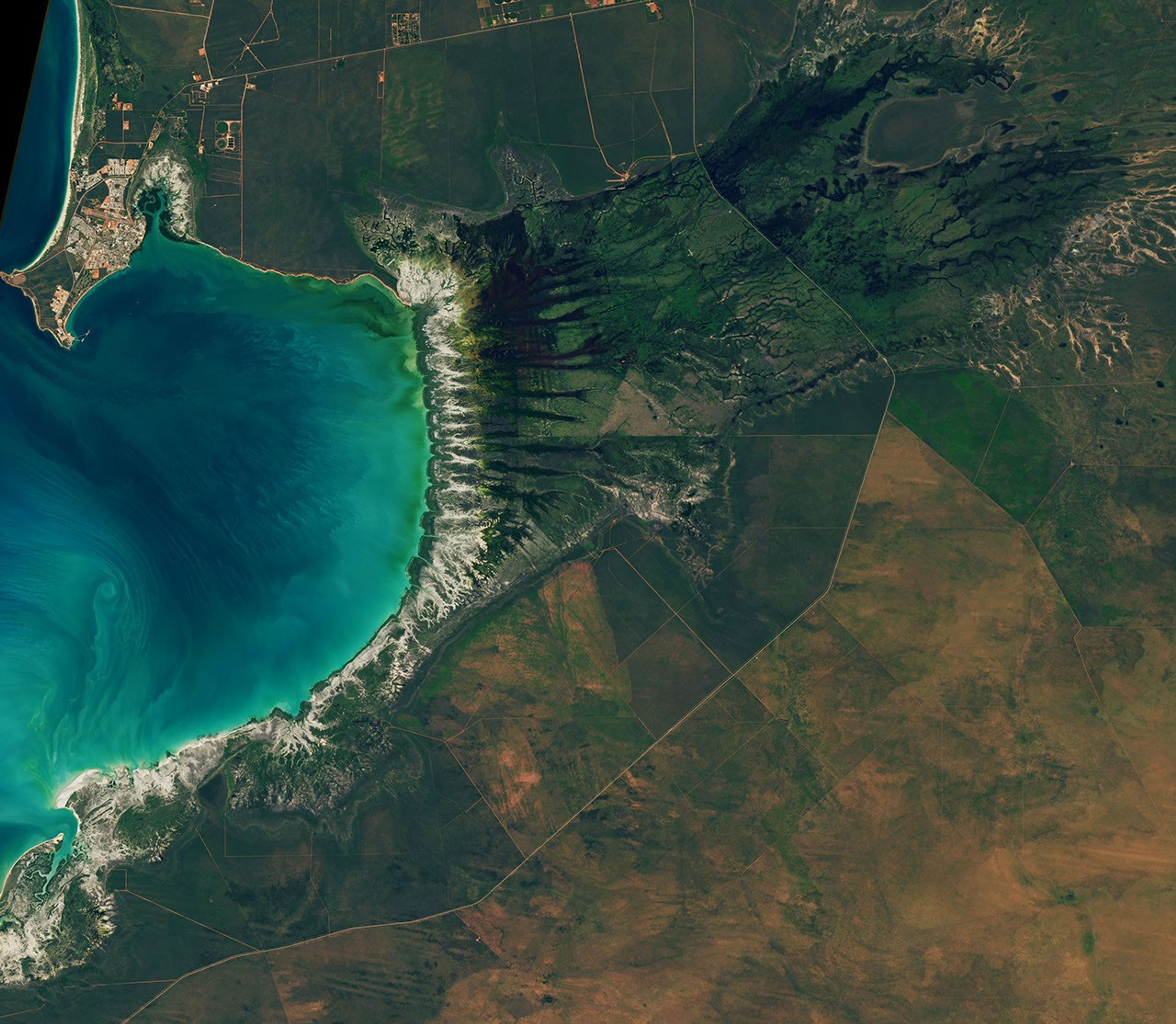
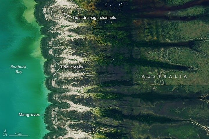
The image at the top of the page shows the bay on March 18, 2026, when water levels were high. Green mangrove forests grow thickly along the shoreline and line the mouths of a network of evenly spaced, linear tidal creeks. These mangrove forests are dynamic. Analysis of decades of Landsat observations shows them expanding westward by nearly 2 meters per year as sediment from the waterways to the east accumulates in the sheltered bay.
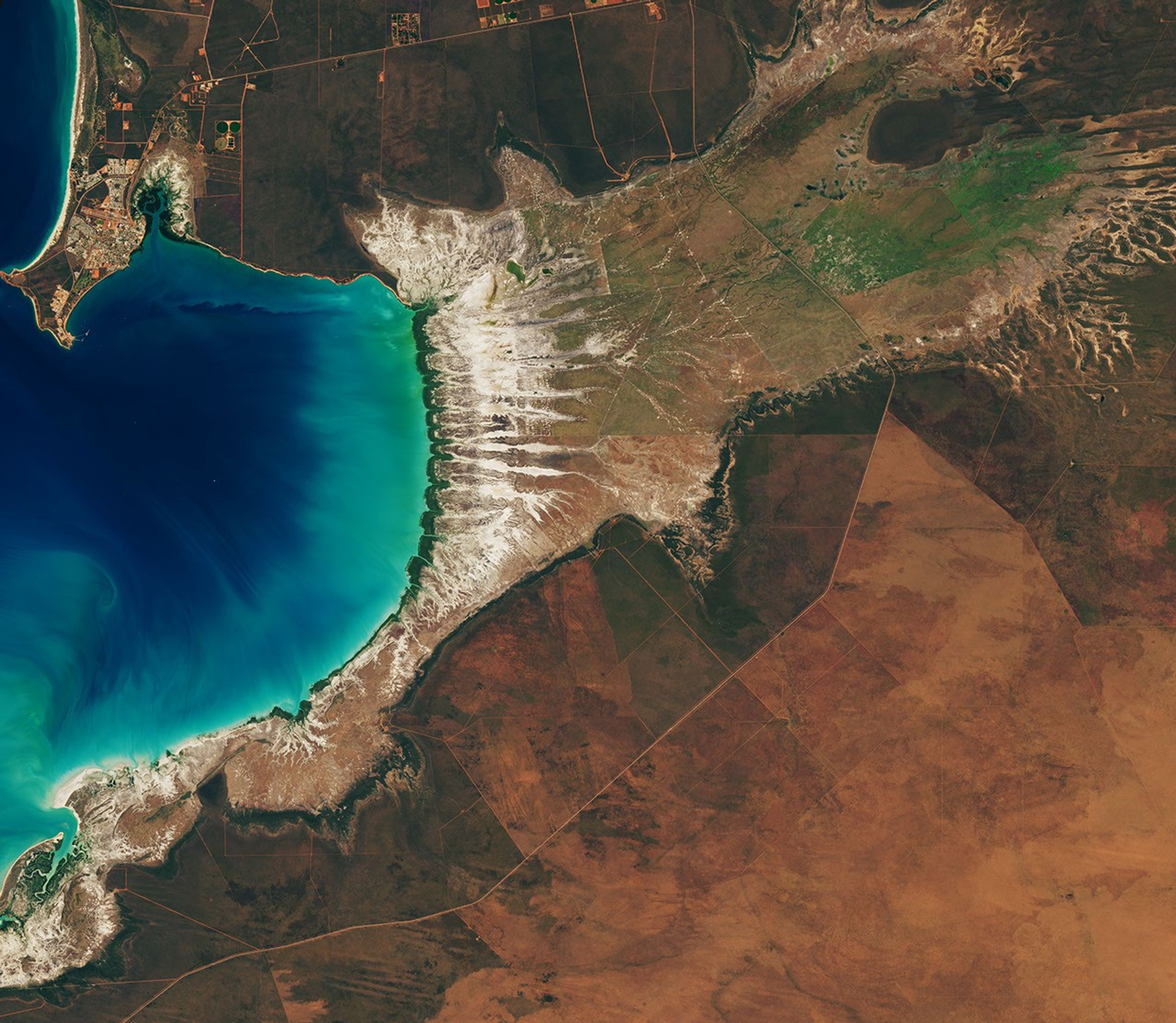
Farther inland, branching networks of tidal drainage channels connect with the tidal creeks, giving the bay its feathered appearance. These channels, partially obscured by thick vegetation in March, were more visible earlier and later in the year, when vegetation was thinner.
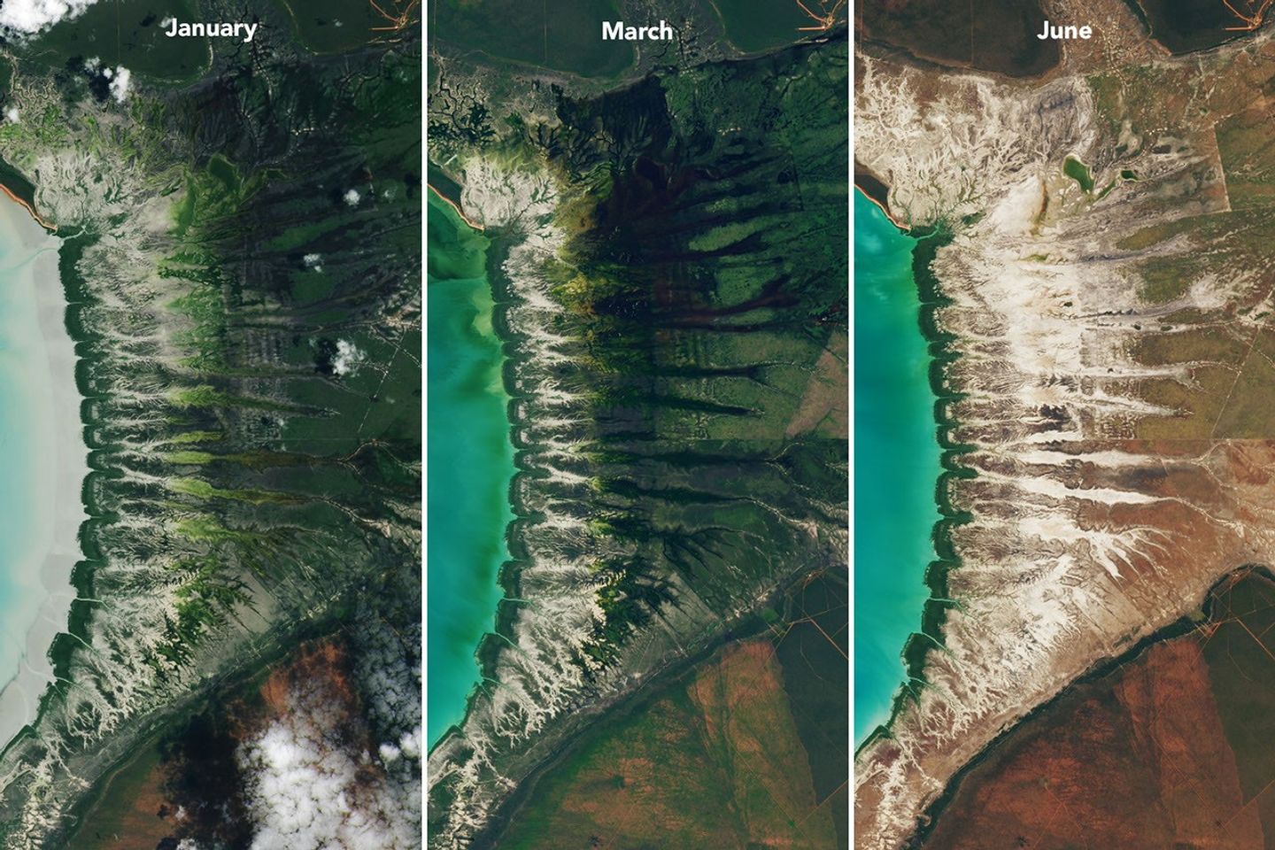
Monsoonal rains, typically falling between December and March, transform the landscape around the bay into lush grasslands and seasonal wetlands. As the rains fade in May and June and the dry season takes hold, these ephemeral grasses and sedge ecosystems die back, turning the landscape shades of gold and brown. The consistent spacing of the tidal creeks is likely not a tidal effect; it appears to be influenced by the regular spacing of linear dunes in the broader region, as seen in the plains to the east.
The bay’s dramatic tidal and seasonal changes are striking from above, and they also support a bounty of life on the ground. The mangroves serve as nurseries for crustaceans and fish, and the mudflats teem with dozens of types of invertebrates, including snails, worms, crabs, clams, and cockles. Shells and snails can reach an abundance of 2,500 per square meter, according to the Australian government.
This bounty of marine life is a major draw for birds. The bay, one of the most important sites for migratory birds in Australia and a key stop on the East Asian-Australasian Flyway, regularly hosts hundreds of thousands of birds, including plovers, godwits, and knots.
NASA Earth Observatory images by Lauren Dauphin, using Landsat data from the U.S. Geological Survey. Story by Adam Voiland.
References & Resources
- Birdlife International (2026) Roebuck Bay. Accessed August 10, 2026.
- Brockmann Consult (2025) Roebuck Bay. Accessed August 10, 2026.
- Brocx, M., via Researchgate (2016) Roebuck Plains, north-western Australia – a major Holocene carbonate mud deposit of international geoheritage significance. Accessed August 10, 2026.
- Broome Bird Observatory, A Special Place for Birds. Accessed August 10, 2026.
- Department of Climate Change, Energy, the Environment and Water (2025, December 15) Roebuck Bay. Accessed August 10, 2026.
- Department of Environment and Conservation (2009) Ecological Character Description for Roebuck Bay. Accessed August 10, 2026.
- Hickey, R. (2019) Tidal inundation modeling within GIS. Journal of Coastal Conservation, 23, 599–606.
- Marine Waters (2020, May 12) Roebuck Bay. Accessed August 10, 2026.
- NASA (2019, June 27) More than Naught: The “Z” of Where Land Meets Sea. Accessed August 10, 2026.
- NASA Earth Observatory (2016, February 15) Compelling Coastline along Roebuck Bay. Accessed August 10, 2026.
- Nanson, R., et al. (2022) Geomorphic insights into Australia’s coastal change using a national dataset derived from the multi-decadal Landsat archive. Estuarine, Coastal and Shelf Science, 265, 107712.
- Piersma, T., et al. (2016) Anna Plains and Roebuck Bay Benthic Invertebrate Mapping 2016. AnnRoeBIM16, 96.
You may also be interested in:
Stay up-to-date with the latest content from NASA as we explore the universe and discover more about our home planet.

After the Laurentide Ice Sheet retreated from present-day Hudson Bay, rebounding land has revealed striking nearshore topography.
Differences in the underlying bedrock and how rivers distribute sediment make the coastlines west of Portland look unlike those northeast…
Urban development, green spaces, and maritime activity converge in this Northern California city.




 August 11, 2026 at 09:31AM from NASA https://ift.tt/ZWiPRK7

Comments
Post a Comment