Eruption at Mayon

At any given moment, about 20 volcanoes on Earth are actively erupting. Often among them is Mayon—the most active volcano in the Philippines. The nearly symmetrical stratovolcano, on Luzon Island near the Albay and Lagonoy gulfs, rises more than 2,400 meters (8,000 feet) above sea level.
Historical records indicate Mayon has erupted 65 times in the past 5,000 years, with the latest episode beginning in January 2026. The Philippine Institute of Volcanology and Seismology (PHIVOLCS) first reported increased rockfalls near the volcano’s summit and inflation of the mountain’s upper slopes. On January 6, the alert level was increased to three on a five-level scale after lava began flowing from the crater and hot clouds of ash and debris called pyroclastic flows (also called pyroclastic density currents) moved down one side of the mountain.
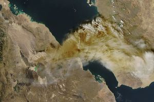
The volcano was still puffing and lava flowing on February 26, when the OLI (Operational Land Imager) on Landsat 8 acquired this rare, relatively clear image. The natural-color scene is overlaid with infrared observations to highlight the lava’s heat signature. On that day, PHIVOLCS reported volcanic earthquakes, rockfalls, and pyroclastic flows. The longest pyroclastic flow had traveled about 4 kilometers (3 miles) through the Mi-isi Gully on the southeast flank.
The level-three alert, which remained in place in March, prompted evacuations within a 6-kilometer (4-mile) radius of the crater, displacing hundreds of families from communities including Tabaco City, Malilpot, and Camalig. Past pyroclastic flows have proven extremely destructive, leading to more than 1,000 deaths in 1814, at least 400 deaths in 1897, and 77 deaths in 1993. More than 73,000 people were evacuated during an eruption in 1984.
Sulfur dioxide (SO2) emissions during the current eruption have averaged 2,466 tons per day, with a peak of 6,569 metric tons measured on February 4, 2026. That is the highest SO2 emission level for one day in 15 years, the PHIVOLCS announced in early February. That was later exceeded on March 6, when SO2 emissions reached as high as 7,633 metric tons.
Multiple NASA satellites have also monitored the volcano’s sulfur dioxide emissions, showing sizable plumes of the gas drifting southwest on February 4 and March 6. The Philippine volcanology institute reported a peak in other activity on February 8 and 9, with 469 rockfalls, 12 major pyroclastic flows, and ashfall in the municipalities of Camalig and Guinobatan.
NASA Earth Observatory image by Michala Garrison, using Landsat data from the U.S. Geological Survey. Story by Adam Voiland.

References & Resources
- Chan, H. & Konstantinou, K. (2020) Multiscale and multitemporal surface temperature monitoring by satellite thermal infrared imagery at Mayon Volcano, Philippines. Journal of Volcanology and Geothermal Research, 401, 106976.
- Global Volcanism Program (2026) Mayon. Accessed March 12, 2026.
- GMA News Online (2026, January 6) Six Albay towns evacuate residents amid Mayon Volcano Alert Level 3 status. Accessed March 12, 2026.
- NASA Earthdata (2023, January 25) Monitoring Volcanic Sulfur Dioxide Emissions. Accessed March 12, 2026.
- NASA Earth Observatory (2009, December 15) Mayon Volcano Threatens Major Eruption. Accessed March 12, 2026.
- PHIVOLCS (2026, March 12) Latest volcano bulletins, advisories, updates & other issuances, or archived issuances. Accessed March 12, 2026.
- PHIVOLCS (2026, February 10) Mayon Volcano Eruption Update. Accessed March 12, 2026.
- Ruth, D.C.S. & Costa, F. (2021) A petrological and conceptual model of Mayon volcano (Philippines) as an example of an open-vent volcano. Bulletin of Volcanology, 83(62).
You may also be interested in:
Stay up-to-date with the latest content from NASA as we explore the universe and discover more about our home planet.
In its first documented eruption, the Ethiopian volcano sent a plume of gas and ash drifting across continents.

The volcano on Russia’s Kamchatka Peninsula continues to erupt after centuries of quiescence.
The volcano in Hawaii is one of the most active in the world, and NASA tech makes it easier for…


 March 13, 2026 at 09:31AM from NASA https://ift.tt/Kb2M6UW

Comments
Post a Comment